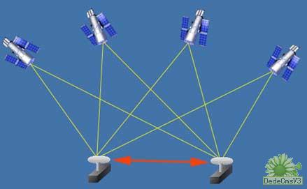
Conventional GPS measurement methods, such as static, fast static, and dynamic measurements, need to be solved afterwards to obtain centimeter-level accuracy, and RTK is a measurement method that can obtain centimeter-level positioning accuracy in the field in real time. It uses carrier phase dynamic real-time The difference (Real-time kinematic) method is a major milestone in the application of GPS. Its emergence has brought new dawn to engineering lofting, topographic mapping, and various control measurements, greatly improving the efficiency of field operations. Carrier phase observations must be used for high-precision GPS measurement. RTK positioning technology is a real-time dynamic positioning technology based on carrier phase observations. It can provide real-time 3D positioning results of the measurement station in a specified coordinate system and achieve centimeter-level accuracy. In RTK operation mode, the base station transmits its observation value and station coordinate information to the rover through the data link. The rover not only receives the data from the reference station through the data link, but also collects the GPS observation data, and composes the differential observation value in the system for real-time processing, and at the same time gives the centimeter-level positioning result, which takes less than one second. The rover can be in a static state or in a moving state; it can be initialized at a fixed point before entering dynamic operation, or it can be directly turned on under dynamic conditions, and the search and solution of weekly ambiguity can be completed in a dynamic environment. After the knowledge solution is fixed throughout the weekend, each epoch can be processed in real time. As long as the tracking of the phase observations of more than four satellites and the necessary geometry can be maintained, the rover can always give centimeter-level positioning results.
The key of RTK technology is data processing technology and data transmission technology. During RTK positioning, the base station receiver is required to transmit the observation data (pseudorange observation value, phase observation value) and known data to the rover receiver in real time. Large, generally require a baud rate of 9600, which is not difficult to achieve on the radio.
How to apply RTK technology
1. Various control surveys The traditional geodetic and engineering control surveys use the method of triangulation and wire netting to measure. Not only is it time-consuming and time-consuming, it requires visual inspection between points, but the accuracy distribution is uneven, and the accuracy is unknown in the field. GPS static measurement, fast static, and pseudo-dynamic methods can't know the positioning accuracy in real time during field surveying and setting. If the accuracy is not satisfactory after returning to the internal processing after surveying and setting up, RTK must be used instead Control measurement can know the positioning accuracy in real time. If the point accuracy requirements are met, the user can stop the observation and know the quality of the observation, which can greatly improve the operation efficiency. If RTK is used for highway control survey, electronic circuit control survey, water conservancy engineering control survey, and geodetic survey, it can not only greatly reduce manpower intensity, save costs, but also greatly improve work efficiency. Measuring a control point in minutes or even seconds It can be done in minutes.
2. Topographic surveying In the past, when measuring topographical maps, firstly, a root control point must be established in the survey area, and then a total station or theodolite should be mounted on the root control point to cooperate with a small flat panel survey. Now it has developed into a field total station and electronic The handbook cooperates with the feature coding, and uses large-scale mapping software to carry out mapping. Even the development of the recent field electronic tablet mapping, etc., all require the measurement of the surrounding terrain and other broken points on the station. These The detail points are all in sight with the measuring station, and generally require at least 2-3 people to operate. Once the accuracy is not satisfactory during the puzzle, the field must be returned to the field. Now when RTK is used, only one person is required to carry the instrument. The topographic and topographic features are left for a second or two, and the feature code is entered at the same time. The point accuracy can be known in real time through the handbook. After measuring an area and returning to the room, the required software interface can output the required Topographic map, which only needs one person to operate with RTK, and does not require visual inspection between points, which greatly improves work efficiency. Using RTK and electronic handbook can measure and set various topographic maps, such as ordinary survey maps, railway line strips. FIG Surveying, road line measurement provided topographic map, with the sounder reservoirs can be used to measure terrain, marine navigational mapping and the like.
3. Lofting is a branch of measurement. It requires a certain method to use a certain instrument to calibrate the artificially designed points on the field. In the past, many conventional methods of lofting have been used, such as the intersection of theodolite intersection and the total station. Wait, when you want to stake out a design point, you often need to move the target back and forth, and it needs 2-3 people to operate. At the same time, it also requires good visibility between the points during the stakeout process, and the efficiency is not very high in production applications. Sometimes, if you encounter difficulties in setting out, you can resort to a lot of methods. If you use RTK technology to set out, you only need to input the designed point coordinates into the electronic handbook, carrying the GPS receiver, it will remind you to go It is fast and convenient to get to the position of the point to be staked out. Because GPS is directly staked out through coordinates, and the accuracy is very high and uniform, the efficiency in field stakeout will be greatly improved, and only one person needs to operate.
Carbide Milling cutters can be divided into standard milling cutters and non-standard milling cutters. Non-standard cutters refer to tools that need to be specially designed and manufactured, such as forming cutters.
The milling cutter also has 2-flute milling cutter, 3-flute milling cutter, 4-flute milling cutter, and 6-flute milling cutter, etc.


Customized Milling Cutter,Custom Milling,Custom Cnc Milling,Custom Milling And Machining
ROYI CNC TOOL TAIXING CITY CO.,LTD , https://www.royitools.com